Sunday, October 16, 2011

GRAND CANYON FROM THE TOP plus aerial views of two large lakes near Phoenix


The last part of our 9000 mile, 5 month trip was to meet Jo’s son Jeff,  sister Barbara, husband Mike, niece Laura and grandniece Katie at Grand Canyon for 3 days. I had not visited the South Rim for many years.

IMG_8798 

This is from the Desert View observation point, the easternmost in the Grand Canyon National Park. In the background is the stretch of the Colorado River from which we could see the south rim when rafting. It is just downstream from where the Little Colorado joins the Colorado.


IMG_8802hShadows cast by clouds help to give a better idea of the vastness of the canyon.


IMG_8803

Jo at another observation point.


IMG_8804

Here is part of the trail taken by those who prefer to ride the mules every day to the point overlooking the river. The wooded area  is Indian Gardens

aIMG_8805

Elk wander freely in the park. The bull keeping track of his harem is at the far left.


IMG_8808

The thunderstorm is over the North Rim.


IMG_8812

Here is most of our party at Hermit’s Rest, the westernmost observation point in the park: Jo, Jeff, Laura, Barbara and Mike.

IMG_8814

Soft morning light also helps to show depth in the photos. Here the camera is pointed at the area where the two passenger jets went down which collided in midair over the canyon in 1956 .

IMG_8817

Jo and I had a nice flight with Jerry and Nancy Grout on Oct. 15. Here is part of Lake Roosevelt from the air. The light area in the foreground is a reflection from the plane’s window.


IMG_8819

Saguaro Lake, with the dam creating it in the middle left. Saguaro is the lake on the Salt River chain of lakes closest to the metropolitan area. Sorry about the reflections, but at 150 mph it is not safe to open the plane’s door for an unobstructed view!

SAN JUAN MOUNTAINS –YANKEE BOY BASIN


From Breckenridge, we journeyed southwest to the San Juan Mountains, which I have visited 32 of the last 33 years.  This year we camped at Ridgway State Park as it was convenient for visiting friends. Beside, I  prefer to avoid driving the motor home up the Million Dollar Highway in Uncompaghre  Canyon and over Red Mountain Pass to Silverton.

IMG_8773

The aspens were beginning to turn color at Silverton – the D&SNG tracks are in the foreground.

  IMG_8771

How is this for dramatic color?

IMG_8774

Here is more beginnings of “color” at Silverton.


IMG_8776

This is a “one of a kind” observation car used on the D&SNG we saw at Silverton.


IMG_8777

We are near Ouray, on our way up Yankee Boy Basin road with Jerry and Jill Wedlake.

IMG_8778

The aspens are just starting to turn in the lower part of Yankee Boy.

IMG_8779

Mill and tailings from the Yankee Boy road.


IMG_8782

If you look closely, here are the twin water falls shown on Coors beer labels.

IMG_8783

Here we are around timberline on our beautiful day of  4 wheeling.

IMG_8786

Yes, that is our road in the lower right!

IMG_8794

This is the trailhead near the end of Yankee Boy, elevation 12,500 ft. Our Jeep climbed it without any problem. Jo Jill and Jerry are next to our Jeep.

Thursday, September 29, 2011

BRECKENRIDGE 4 WHEELERS RALLY PART 1


THE RALLY

We enjoyed  the week of Sept. 18 – 25 attending  a rally of the Family Motor Coach 4 Wheelers in a very nice RV park in Breckenridge CO. It was the group’s first rally there, but advance scouting and creating GPS tracks resulted in many trails being planned for the approximately 80 people attending. Before the rally began, the weather was cool and rainy, with some snow dusting the higher peaks. The aspens just began to turn yellow early in the week, but as it progressed more turned yellow and some even orange tinted.

IMG_8685

The unusual cloud at the right suggests to me that a snow squall may be going on. The picture was taken looking north from Hoosier Pass.

IMG_8687

This Jeep has run Rubicon, about the most difficult trail in the West.

IMG_8686

The owners of these Jeeps were just bragging!

IMG_8688

This lineup is more typical of the Jeeps driven by those attending. There also were some very Plain Jane Jeeps in the group, as well as a handful of Grand Cherokees such as ours. 

OUR FIRST DAY’S RUN

IMG_8689

Our first run was up Peru Creek to the ruins if the Pennsylvania mill, with corresponding mine up the mountain. Below are parts of the machinery still at the mill ruins.IMG_8691

IMG_8693

The whitish line in the upper left is the Argentine wagon road. It has been closed many years due to slides blocking the road. One can nearly get up to the pass from the other side.

IMG_8696

Lunch time on the ridge of Glacier Mountain

IMG_8702

Here is our road running the top of Glacier Mountain. We are above timber line, maybe around 12,000 ft.

IMG_8701

Here is our little caravan making the run. Ours is the third vehicle. Lifting it 2 inches and putting on taller all terrain tires (it is otherwise a stock vehicle as it came from the factory) have helped its performance remarkably, as well as  boosting my confidence considerably!    Note the dusting of snow on the far peaks.

IMG_8704 

Our descent from Glacier Mountain was down the canyon of the North Fork of the Swan River. (Sorry that the dating system in the camera suddenly became a day fast!)

IMG_8710

The most challenging part of the run was descending the right fork of the Y of the road nearly on the horizon to get into the valley of the North Fork of the Swan River.

BRECKENRIDGE 4 WHEELERS RALLY PART 2 BOREAS PASS, COMO ROUNDHOUSE and SOUTH PARK CITY MUSEUM

Jo and I were the leaders of this History Trail run on Sept. 21. We only had three Jeeps, perhaps because the run easily could be made in a passenger car. I gave as much historical information to the pass as I could. Boreas Pass was used by the Denver, South Park & Pacific Railroad’s Highline to connect  Leadville and Denver, beating the Denver & Rio Grande to the lucrative market during the Leadville boom.
IMG_8712

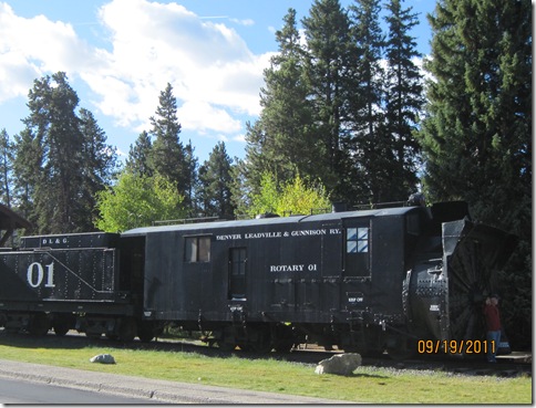
At the Breckenridge end of the pass road was a static display of this rotary snow remover and its tender.  It has a steam engine on board, but all it is used for is powering the rotary blades. It is pushed by steam engines in removing deep snow from the tracks.

IMG_8722

Many of the Breckenridge ski runs are seen from the Boreas Pass road.


IMG_8726 

On the way up we paused at the Baker Tank, one of three tanks originally on the pass.

IMG_8729

Section house and other buildings at the pass. The two larger buildings have been restored and are available for rent by skiers in the winter. The building at the rear is a comfort station.
IMG_8715

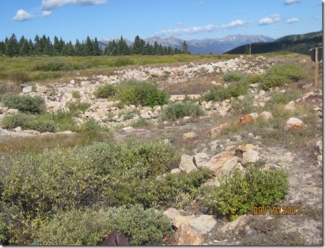
This is the remains of the collapsed stone engine house which contained a water tub for the thirsty locomotives and a turntable in the building to turn the steam engines. (They performed better going nose first than in reverse, tender first.)

IMG_8714

Looking down in the pit for the turntable. Turntables almost always are located outside of buildings, but it probably was built inside the engine house to make it easier to turn them in the deep snows found at this high pass (almost 11,500 ft. elevation).


IMG_8728

View from the section house of the pass area, with the engine house ruins at the right of the boxcar.

 IMG_8733

Part way down on the south side of the pass the road deviates from the old railroad bed, and visitors are encouraged to walk out to Rocky Point on the old roadbed. A few panels of narrow gauge track have been re-laid on the path

 IMG_8717

From the Boreas Pass road one looks down the large valley named South Park,. The South Platte River heads in the valley.

 IMG_8731

Here the automobile road runs on top of the old railroad bed, with gentle curves and modest changes in elevation. The aspens were just beginning to be colorful.
 IMG_8737

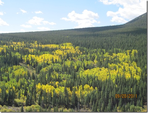
More aspens are turning in the valley

 IMG_8739

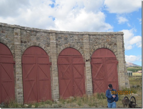
At the south end of the pass is the burg of Como, consisting of a few homes, abandoned buildings, a hotel with a lunch room (where we ate lunch), the depot and the six bay stone part of the Roundhouse . In the heyday of the railroad wood additions were built on one end of the roundhouse, now long gone. The roundhouse slowly is being restored, with more work being done every time a grant can be found.
IMG_8742

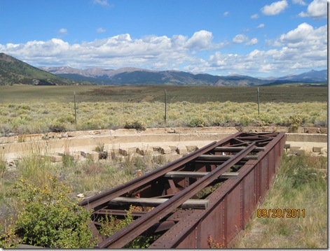
A turntable has been placed on the ground in the turntable pit.
IMG_8743

Half of the existing bays are see here. Stabilization of the outside of the building and the roof has been completed. We were honored to have a tour of the roundhouse led by Bob Schoppe, the president of the Denver, South Park and Pacific Historical Society. It is undertaking the restoration of the Como depot. The current pride and joy of the Society is a boxcar delivered to the DSP&P about 1880. It is stored in the roundhouse awaiting restoration. A restoration survey has been completed so work wan begin when funds become available. The State Historical Fund receives money from gambling taxes which has funded many railroad projects.

 IMG_8750

We wrapped up the day by a visit to the South Park City museum in Fairplay. It consists of 40 historical buildings, some on their original foundations, depicting life in local towns about 1900. Included were a few homes, a dentist’s office, a doctor’s office, a general store, a pharmacy, mine, brewery, livery, church, rail yard, etc. It is very much worth a visit.

 IMG_8751

Jo could not resist playing fireman!


BRECKENRIDGE 4 WHEELERS RALLY PART 3 EMPIRE RESERVOIR AND WESTON PASS

Our run Sept. 23 took highways to Leadville, then up California Gulch to Empire Reservoir nearly at timber line. Next we dropped back into the Arkansas River valley to catch the Weston Pass road back toward Fairplay, and after gong over Hoosier Pass, retuning to the RV park at Breckenridge.

 IMG_8752

Empire Reservoir, probably developed for a water source for mining or milling activities.

DSC_0917

What a view these beavers have!


Great shots of changing fall colors. The orangish color is particularly impressive.

DSC_0910

DSC_0926


DSC_0934


IMG_8755

From the high ridge along which we drove we had great views of the Arkansas River valley, Leadville and Turquoise Lake .


IMG_8756

From high above timberline, the Weston Pass road winds in the distance.  

IMG_8757

Our lunch stop on the way down from the ridge to the Arkansas Valley.

IMG_8758

The aspens here are behind those shown above.

IMG_8759

The Weston Pass road was popular for wagons to use to reach Leadville as (at 11,921 ft.) it was lower than other nearby passes and easier to go over. Parts were toll roads for years. I drove up the west side nearly to the top in 2 wheel high range and shifted into 4 low range near the top for going over rocks and for deceleration going down the east side.