Sunday, August 2, 2015

VERMONT VISIT FOR INFORMATION ON WILLIAM BARSTOW STRONG JULY 15 – 18

Jo and I arrived at Brownington Village July 15. We met the Hobacks at their Inn the morning of July 17 and the four of us met with the Birch family July 18. Tom Hoback has started writing a book on my great grandfather William B Strong (WBS) and wanted a tour of the area where he was born and raised until the family moved to Beloit WI  in 1851. WBS then was 14 years old. Although I had visited Brownington three times before, I learned a lot more about it on this trip.

Pictures are taken by the Canon SX 150 IS.

IMG_0172

After he retired as the President of the Santa Fe RR in 1889, WBS moved to Beloit but spent time in the summers in the village of his  birth.

On Prospect Hill next to the Brownington Congregational Church he had  built a two story observation tower around 1895. For the bicentennial of the United States a replica of the original tower was built. Above is the third iteration of the tower built a few years ago.

IMG_0173a


This tersely worded monument at the base of the tower acknowledges WBS.

IMG_0171 

Jo and I enjoyed this evening view from the tower. Most of the further  large lake is in Canada.


IMG_0175

Here are Jo, Tom and Sue Hoback at the tower. The two lakes are barely visible in the background.


IMG_0178


On July 17 we met with folks at the Orleans County Historical Society in their headquarters building. The efforts of the historical society are focused in the Brownington Village area where they own several buildings. From the left, Katherine French, Tom Hoback, Joan Hugenin and Sue Hoback. 

Katherine French gave us a great overview of the history of the Brownington Village while the Strong family lived there. It was on the main trail (it could hardly be called a road in the early 1800s) from Boston to Montreal.

IMG_0180

This is the building in which WBS father operated a temperance inn – no alcohol was served. Another inn across the road served the imbibers. The family lived in this building from the early 1830s until 1851 when they moved to Beloit.

IMG_0181

The location of the building pictured above is indicated in the above drawing by “Rice and Goings”  on the north side of the road . The building burned after the turn of the century, and a fairly modern house is on the site now.

IMG_0182 

Above is the Alexander Twilight house built about 1830. Across the street is the Old Stone House built about the same time. He called in Athenian Hall.

IMG_0188

Mr.. Twilight put up this building as a dormitory for students who did not live within walking distance from the Orleans County Grammar School located near the Congregational Church. The school building has been moved to another site in the village. The school was a combination high school and junior college. and attracted students from a wide area, even Canada.

IMG_0183

Joan Hugenin    gave us a nice two hour tour of the building, now a museum with various nearby communities featured in separate rooms.  The historical society bought it about 1925 to avoid it being town down for reuse of the building stones.


IMG_0185 

This is Brownington Congregational Church. WBS paid for the steeple being added, plus a bell, now displayed on the ground in front of the church. It bears an inscription that it is in memory of WBS’ grandparents

IMG_0184

IMG_0186

Two generations of Strong's are buried in the church cemetery.

WBS’ SUMMER HOME IN BROWNINGTON AND FAMILY DINNER

Saturday night the Hobacks hosted a dinner at a nearby Inn of the members of the Strong clan gathered. Richard Birch (also a great grandson of WBS), his wife Nancy and their sons Kent and Scott with Jennette and Lindey, their respective wives.


IMG_0220

From left , Jeanette Birch, Jo, Richard Birch and Lindy Birch. At right, Kent Birch and Tom Hoback.


IMG_0222 

Scott Birch, Nancy Birch and Sue Hoback

 IMG_0219 

 Some 1904 family pictures show WBS seated on this very porch of his summer home.The trim on the porch has not been changed in over 100 years! I got athrill of being the same porch as WBS used over a century ago.


 IMG_0215


Yours truly and Scott Birch. He was able to spend most of Saturday with us.


IMG_0218

Thursday, July 30, 2015

NIAGARA FALLS- Part 1 of 4

 On our way east to Vermont, we spent three nights at Niagara Falls. Both of us had been there before, but it had been a long time. These shots were taken on Friday July 10 in a Canon Power Shot SX150 IS.

My advice for those visiting the falls area is avoid the weekend, go early, and bring $$$. Parking lots fill up early and off site parking is dear. We toured only the American Falls, saving for “next time” views from the Canadian side. There is plenty to do and see on just the American side to occupy one for a full day.


IMG_0113

Niagara Falls State Park is the oldest state park in the US. In addition to parking, fees are charged for each of 5 attractions listed above and the trolley. On Friday we did just the trolley and movie.


IMG_0087 

Above is our first view of the Canadian side and the rapids below the falls. Here are the Canadian boats taking tourists up the Niagara River  to close to the foot of the Canadian Horseshoe Falls.

Of the water in the Niagara River leaving Lake Erie, Canada takes 25% and the US takes 25% for generating electricity. 80% of the remaining water goes over Horseshoe Falls and the rest over the American Falls.


IMG_0090

Jo at the edge of the American Falls with the skyline of the Canada side in the background.


IMG_0092

Downstream is on the left. An observation bridge in the middle leads to an elevator to take passengers down in elevators to the walkway to Maid of the Mist boats at the foot. I vaguely recall riding the Maid of the Mist boat with my mother in 1941!  Then it was a long walk down!

IMG_0094 

Good view of the American Falls in the foreground with the Horseshoe Falls in the far back.

IMG_0095

We took the trolley over to Goat Island from which we enjoyed views of both falls.

IMG_0097

Looking downstream from Goat Island with mist at the right from the American Falls.

IMG_0099

Water level view of the edge of Horseshoe Falls.

IMG_0100

The rapids above the Horseshoe Falls drop 40 feet.


IMG_0106

 View from Goat Island showing most of Horseshoe Falls. The mist column always is there.


IMG_0107

View from Goat Island of the American Falls. The observation area is on Luna Island at the top of the Bridal Veil part of the American Falls.


NIAGARA FALLS - Part 2

On Sat. July 11 we took a commercial tour of the American side with 15 others folks. We saw parts in detail which we bypassed the day before.

 IMG_0125


Our guide, Eric, teaches History in a local junior high school. He did a fine job of showing us some of the sights and avoiding long lines to the more popular attractions.

IMG_0116


Today’s tour began downstream from the falls where cable cars run across the gorge, with boarding  the Canadian side.

IMG_0117

Cable car riders get a great view of the whirlpool at the end of the rapids. Our guide said that a body entering the whirlpool will emerge downstream about 6 months later.


IMG_0121

 Here are the rapids in the gorge looking upstream from the whirlpool.


IMG_0126

This view of Horseshoe falls differs from that of the day before due to the wind pushing the mist away from the falls.


IMG_0130

We were treated  to a rainbow in the mist.

IMG_0131

Our view of the day!

NIAGARA FALLS – Part 3

 Our next adventure on the tour was Cave of the Winds. It was not really a cave but a very wet walk on steps beside Bridal Veil falls up close and personal.

The ticket price included the yellow rain ponchos here and sandals, presumably to make the walking less slippery.

Our guide collected our shoes and sox, returning them when we returned to the bus. Very convenient. Those on their own carried their shoes in plastic bags.


IMG_0135


The red wooden walkways and platforms are erected every spring and taken down in the winter to avoid being destroyed by the winter’s ice. Horseshoe Falls is at the left and an abandoned power plant is on the Canadian side. Below, gulls find the area fine for nesting.

 IMG_0136


IMG_0138

 The falls are more impressive looking up at them from near the bottom.


IMG_0139

The sound and force of the falling water is experienced so close to it.


IMG_0141

The rocks fall from the upper part of the falls as the force of the water erodes the lip of the falls up the Niagara River.


IMG_0143

Here is the crowded Canadian tour boat.

IMG_0144

Much of the walk is directly over water just coming over the falls.

IMG_0145

This platform is aptly called the Hurricane Deck. Jo is at the right. Picture taking opportunities were limited by having to keep the camera dry.

NIAGARA FALLS – Part 4 - Maid of the Mist

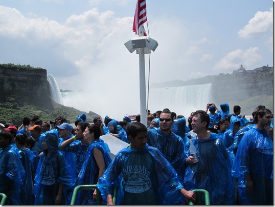
Four large elevators took the passengers down to near river level. After an walk down more, we were issued blue rain ponchos, with our guide instructing us not to put them on until the boat disembarked, as one gets sweaty wearing them while in the sun. Most ignored the advice.

 IMG_0148

The two Maid of the Mist boats (VI and VII) were able to keep up with the steady stream of passengers coming down the elevators.


IMG_0149

Here is most of the width of the American Falls from the boat.


IMG_0152

At the left is the tower for the elevators

IMG_0153


At the center is Bridal Veil Falls with the Cave of the Winds walkways .


IMG_0157

The gentleman at the left helped Jo put on her poncho.

IMG_0158

 Lots of gulls chose to take a mass afternoon flight.

IMG_0159

Across the river on the Canadian side is the building and walkway for those on that side to take a walk under Horseshoe

Falls.


IMG_0163

The width of Horseshoe Falls is visible here.


IMG_0165

As we approach the place for disembarking, the other boat at left is preparing to leave with the next load of tourists.


IMG_0168

Here are nice views of the American Falls from the top of the walkway where the elevators are loaded.


IMG_0170